The Atlantic Route and the Punic Coins
The Atlantic region north and south of the Straits of Gibraltar was a strategically important area of Phoenician influence. The border with the Greek and Roman worlds, as a clear separation from these political systems, stretched north and west of the Mediterranean across Sicily to the Pillars of Heracles. Inside this border, strongly marked by ideology, were the politically and economically important and protected Punic territories ‘beyond the Bel Promontorio’, forbidden to the Romans in the first treaty with Rome (Polybius III, 22-23). This frontier did not have a defined route in all its parts, but clearly delineated areas of influence. The earliest evidence of Phoenician knowledge of the Atlantic route comes from the account of the voyage made in the 5th century BC by the Carthaginian Imilcone, who, according to the accounts of Pliny and Avienus, sailed north along the Atlantic coast on a four-month expedition and, skirting the oceanic coast of France, reached Brittany and possibly the Cassiterides (gr. Κασσιτερίδες), the name given in ancient times to several islands of the south-western British archipelago and Cornwall because of their tin deposits (gr. κασσίτερος). Interesting in this regard is Strabo’s account (Geography, III, 5, 11) of a Punic shipowner sailing north from Cádiz who, realising that he was being followed by Roman spy ships, chose to run his ship aground on the rocks rather than lead his pursuers along that route. After saving himself and returning to Carthage, he was rewarded and reimbursed for his lost cargo. We do not know what goods he was carrying, but we can certainly assume that the secrecy of the route was linked to the metal trade, one of the main economic needs that, from the beginning of the 8th century BC, determined the Phoenician frequency of the Iberian Peninsula with Cadiz, A pole of attraction and radiance in the management of the trade network of the far west, which stretched from the mouth of the Tagus to the valley of the Quadalquivir, to Lixus and Mogador in Atlantic Morocco, to Extremadura and the westernmost area of the Meseta. The site on which ancient Gades stands is a strategic one, located at the confluence of three great trade routes that existed before the Phoenician foundation itself: the Atlantic, the Mediterranean and the Tartessian.
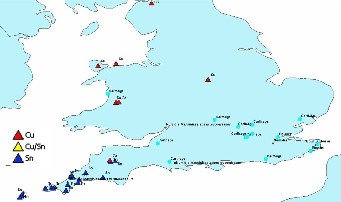
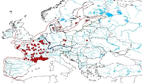
Atlantic Route : Punic Coins in Britannia
From the Spanish coast, the route must have continued along the French coast, as evidenced by the discovery of Punic coins at Bidart (Pyrenees, Atlantic side), Soulac (Gironde), Les sables d’Olonne and l’île de Noirmoutier (Vendée), Quimper and Penmarc’h (Sud Finistère), Ploulec’h (Côtes-du-Nord). One proposal for the Gironde seems noteworthy. L. Murin, for the site of Les Santons, where an interesting quantity of Greek coins has been found, highlighting the role of “relais joué par le pays santons à l’une des extremités de l’isthme gaulois”, hypothesises that the site could have been the meeting point between the Atlantic sea route and the river route along the Loire, which started from Massalia for the supply of metals and which, like the Phoenician sea route, was kept secret by the Greeks.
In this research perspective, the Punic and Neo-Punic coins found on the southern coasts of Britain are of particular importance. Now, and based on the published material only, the number of specimens found on British territory is 104: this aspect of the research must also be studied in depth, but it seems interesting to us to recall the data reported by J. M. Doyen on the discovery at Naxos. Doyen on the discovery of the skeleton of a Cercopithecus (Macaque sylvanus) native to the area of the Strait of Gibraltar, in a late Hallstatt context, at the Fort of Navan in Ireland, which for the scholar is a clear indication of the animal’s “Phoenician” origin.